Young Marie Tharp thought her dad had the best job ever. He traveled around the country making maps. His maps were special—they revealed hidden things. They showed where different kinds of soil and wet and dry places were. That helped farmers know what to plant.
Marie’s dad taught her how to draw maps. They moved around a lot. Marie changed schools often. But she loved to see the country, draw, and play her violin.
In college, Marie tried lots of different subjects. Her father always told her, “When you find your life’s work, make sure it is something you can do, and most important, something you like to do.” She took classes in ar
Then one day, her geology teacher pointed to a big map of Earth. Almost three-fourths of it was plain blue ocean. What was under all that water? Was it flat, like a beach? Or were there mountains and valleys, as on land? No one knew. That got Marie’s attention. All that blue blank space—waiting to be ma
Exploring with Numbers
Marie became a geologist. In 1948, she got a job with a group studying the oceans. But women were not allowed to work aboard research ships at the time. Marie’s job was to stay in the office to do math and draw. But that didn’t mean she couldn’t explore.
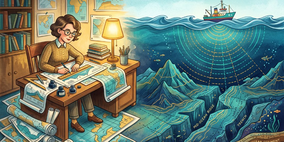
Part of Marie’s job was to keep track of all the data that the ships sent back. One number she often wrote down was the depth of the water. Ships measured this with sonar—sending out a sound ping and timing the e
Marie’s office had huge books listing how deep the ocean was along routes where ships sailed. Over the years, many sailors had noticed that the water got shallower down the middle of the Atlantic Ocean. Were there mountains under the sea? All those books filled with depth measurements gave Marie an idea. Could she use them to make a new kind of map—of the whole seafloor?
She plotted the numbers on graphs. Each graph made a picture of the depth along a line east to west, like a slice of the seafloor. She put the slices together to make a 3D map. Where the soundings showed a deep bottom, that was a valley or canyon. Where they stayed the same for a long way, that meant a flat plain. The numbers revealed underwater mountains and lots of blank places.
With the help of fellow geologist Bruce Heezen, Marie set out to fill in the empty places. Bruce went out on ships and collected data. Together they made the maps. Ocean scientists from other countries shared their measurements. It took many years. But eventually, all those thousands of depth readings fit together to make the first map of the ocean floor.
Seafloor Surprise
The new map showed that the bottom of the ocean is not flat at all. It is filled with mountains and valleys, just like the land. The map revealed a long line of mountains down the middle of the Atlantic Ocean. The mountains continue on across the whole globe, like the seam on a baseball.
In the middle of these mountains was another surprise—a long rift or crack, right down the center. That rift helped solve an old puzzle.
In 1915, German geologist Alfred Wegener had come up with a truly wild idea. He suggested that the continents move. Wegener said that the reason South America and Africa look like they should fit together is because they once did. The continents had drifted apart.
This idea seemed so strange that not many people believed Wegener. After all, how could huge pieces of Earth’s crust move? Geologists had been arguing about Wegener’s idea ever since.
But Marie’s map proved Wegener right. Its undersea mountains traced the edges of big, rocky plates. Where
Modern satellites can now actually measure the continents mov
| Word | US Phonetic | Simple Definition | معنی فارسی |
| Geology | /dʒiˈɑː.lə.dʒi/ | The study of the Earth and rocks | زمینشناسی |
| Sonar | /ˈsoʊ.nɑːr/ | Using sound waves to find underwater objects | سیستم ردیابی صوتی زیر آب (سونار) |
| Echo | /ˈek.oʊ/ | A sound that bounces back off a surface | پژواک / بازتاب صدا |
| Depth | /depθ/ | The distance from top to bottom | عمق / ژرفا |
| Seafloor | /ˈsiː.flɔːr/ | The bottom of the ocean | بستر دریا / کف اقیانوس |
| Shallow | /ˈʃæl.oʊ/ | Not deep | کمعمق |
| Plot | /plɑːt/ | To mark points on a graph or map | رسم کردن / نقطهگذاری روی نمودار |
| Canyon | /ˈkæn.jən/ | A deep valley with steep rock sides | دره عمیق و باریک |
| Rift | /rɪft/ | A large crack or split in rock or earth | شکاف / درز عمیق |
| Continent | /ˈkɑːn.t̬ən.ənt/ | One of the large land masses of the Earth | قاره |
| Drift | /drɪft/ | To move slowly along without control | بهآرامی حرکت کردن / شناور بودن |
| Crust | /krʌst/ | The hard outer layer of Earth | پوسته زمین |
| Plate | /pleɪt/ | A huge moving section of Earth's crust | صفحه تکتونیکی زمین |
| Magma | /ˈmæɡ.mə/ | Hot liquid rock under the Earth's surface | گدازه درونزمین / ماگما |
| Trench | /trentʃ/ | A long, very deep hole in the seafloor | گودال عمیق زیردریایی |
| Trigger | /ˈtrɪɡ.ɚ/ | To cause something to start happening | تحریک کردن / باعث شدن |